

Land Parcel AR
The team at Regrid approached Gravity Jack with the question, “would it be possible to view their land parcels and all of the corresponding data in Augmented Reality?” Our answer? “Absolutely!” Together, our teams quickly got to work taking data from their existing API and reproducing that information into an AR experience that will redefine the future of real estate and land parcel data.
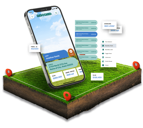
With the Regrid Land Parcel AR application, users can easily search for property boundaries anywhere in the US vis GPS. Once the desired property is selected an AR boundary will appear showcasing the exact dimensions associated with that land parcel. In addition to the AR boundary, the app will showcase property information such as total square footage, property value, and more! Check out the video of the Regrid AR Parcel app in action and see for yourself just how the functionality of seeing land in augmented reality has seemingly endless use cases.
Client
REGRID

Platforms
iOS App Development

SERVICES
Mobile App
Deliver dynamic content to customers in new and exciting ways

Augmented Reality
Place digital experiences within a real-world environment

Localization
Provide specific information based on the user’s location

Backend Framework
Enables the client to easily update details within the app

Motion Graphics
Text and character animations that come to life within the project

User Experience Design
Enhancing the user’s overall experience through thoughtful digital designs

THE PROJECT PROCESS
We are no strangers to creating a completely new project that integrates an already existing API. However, since this app was a demo, the focus of the project was the functionality of showcasing the parcel data in Augmented Reality. To ensure all of the app’s goals were met, the app went through the same process as all of our projects.
TIMELINE STAGES

USER STORIES
A process of identifying and organizing content.

WIREFRAMES
Planning the rough layout and structure of the site’s pages.

UI DESIGN
Applying the styles to the wireframes to achieve the final design.

DEVELOPMENT
Building the website with modern coding techniques.

QUALITY ASSURANCE
Identifying and fixing any bugs in the code on multiple devices and screen sizes.

LAUNCH
Setting up your site on a hosting service or packaging up the code and handing it over to you!

PROJECT DEVELOPMENT
As the leading provider of land parcels, the team at Regrid was looking to take a step into the future with digital data. To make this happen, they partnered with our team at Gravity Jack to create a futuristic mobile application that displays land parcel data in augmented reality. The Regrid AR parcel app has the ability to:
- Leverage GPS to find surrounding land parcels and display them in AR anywhere in the country
- Display additional property information such as ownership, value, zoning, and more
- Shape the property lines in 2 and 3 dimensions
- Measure the distance between points across the parcel
- Adjust the color and transparencies of the AR boundary of the parcel
- Remove any obstructions by viewing the parcel at different angles and elevations
All of which are accompanied by an intuitive UI/UX for all users. As we continue our relationship with Regrid, we now have a strong foundation in the Land Parcel AR demo app to showcase what AR and VR can bring to the real estate and land parcel industry.


ESTABLISHING USER STORIES
Once all of the app’s functionality was determinded, Gravity Jack was then able to create user stories that helped determine a user’s journey throughout the app
User Story Flowcharts
A detailed and comprehensive flowchart to guide the development of your app.


WIREFRAMES
Wireframes included a toggle switch is provided within the AR experience that allows users to view the three different TV sizes in succession so they can find which one best fits their space.
Wireframing
The blueprints of a project that put the design and development teams on the same page prior the development.

MOBILE DESIGNS
While the REGRID demo application was initially developed specifically for iOS devices, the app’s menus, buttons, and other features can transcend accross a variety of platforms and devices
Custom Software
Code development specific to the project’s needs


FINAL DELIVERY
Gravity Jack’s development of the Regird AR parcel app not only streamline’s the process of accessing and viewing land parcels, but is now the standard of what technology can do for the industry.
The Goal
Take Regirid’s existing API filled with parcel information to create a mobile app that is capable of displaying boundaries in Augmented Reality and producing additional property data points.

Gravity Jack’s Solution
Develop a dynamic demo app that harnesses GPS which can then perfectly draw an accurate 2D AR boundry around the parcel which can be viewed from several different perspectives.
The Result
A never been done before mobile application, that does away with blueprints on paper and allows users to digitally view land parcel data in a real-world environment.